


Mapping volcanoes’ ‘hidden’ structures may help predict severity and timing of eruptions


KINGSTON, R.I. – Oct. 31, 2025 – In an effort to predict volcanic eruptions sooner and more accurately, students from the University of Rhode Island’s Graduate School of Oceanography (GSO) are studying the rift zones of two of the most active volcanoes in the world, Hawaii’s Kilauea and Mauna Loa.

A volcanic rift zone is a linear area of weakness on a volcano, often a set of parallel cracks on its flanks, that allows magma to rise to the surface, leading to eruptions and volcanic activity. Rift zones often form due to internal stress from magma pushing the volcano’s flanks apart.
“We’re mapping the volcanoes’ hidden fine structures and how the big regional forces shape and refresh the structures—that combination largely determines where magma goes, how often it gets out, and how big eruptions can be,” said Zhangbao Cheng, a third-year geophysical oceanography Ph.D. student from Wuhan, China.
To explain the activity below a volcano’s surface, Cheng compared a volcano to a building.

“Think of the subsurface like a building’s plumbing and framing. The fine structures are the features that control where magma, gas, and hot fluids can move, such as dense swarms of tiny cracks, narrow dikes and sills, weak zones, etc. The volcano-tectonic settings are the big-picture forces and geometry shaping each rift,” said Cheng. “That’s how the island spreads seaward, where the main faults and rift axes run, how Kilauea and Mauna Loa push/pull on each other, and how deep magma supply loads or unloads the crust.”
URI is the lead institution on this seismological study, which is funded by the National Science Foundation. Students and scientists from the University of Hawaii and the University of Utah are also involved and have assisted with fieldwork and data analyses.
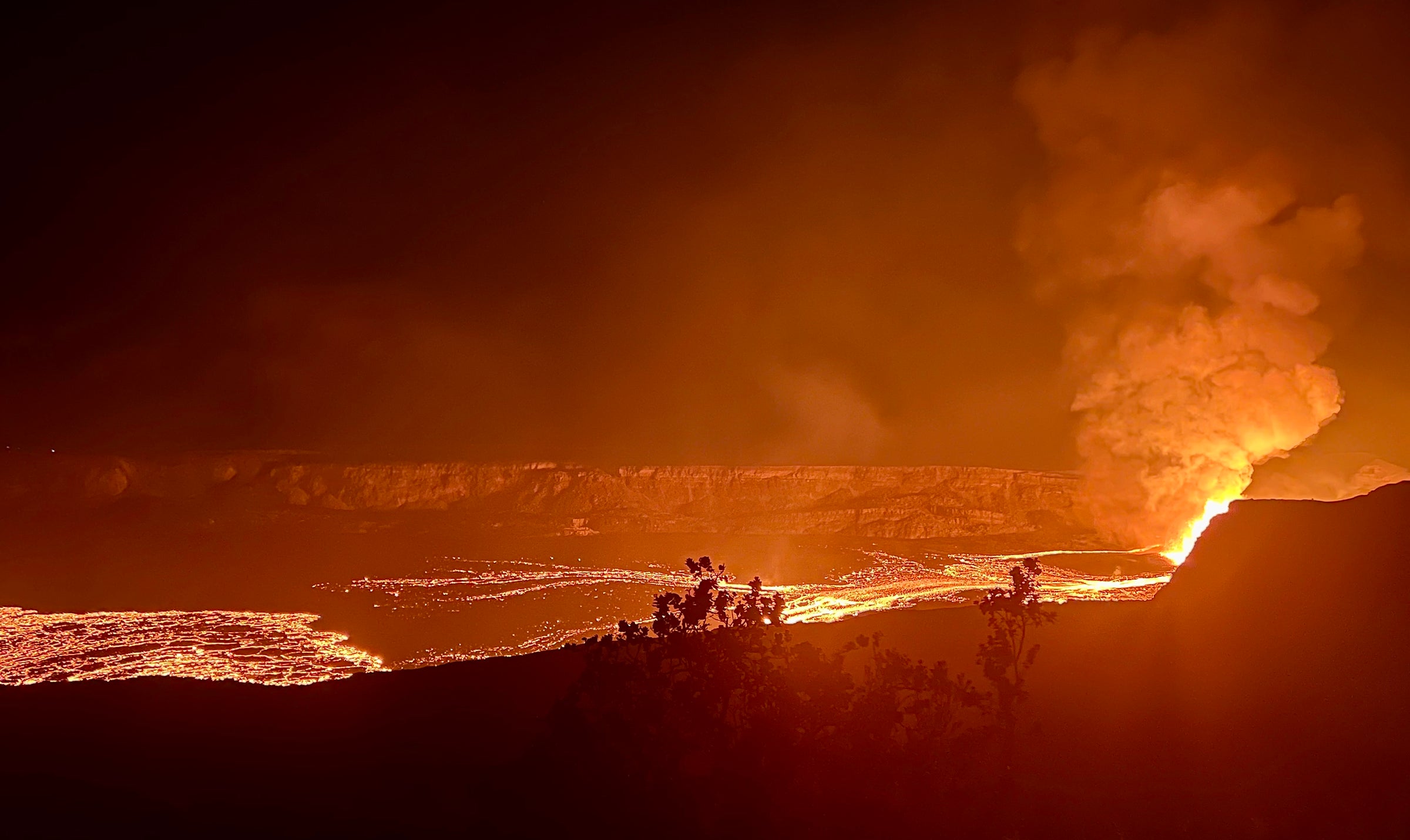
In 2018, an eruption occurred in the Lower East Rift Zone of Kilauea. The eruption lasted for about four months, destroying more than 700 buildings, and resulting in an estimated $800-million-dollar recovery cost. After almost 40 years of dormancy, Mauna Loa erupted in late 2022. The outpouring lava flows from its Northeast Rift Zone almost reached the Daniel K. Inouye Highway, threatening to cut off the only highway connecting the east and northwest coasts of the Island of Hawaii. These two eruptions highlighted the urgent need to better understand the dynamics of volcanic rift zones.

In 2024, during the first year of the project, a team from URI took two trips to Hawaii to deploy and recover seismometers. Four linear arrays consisting of 460 autonomous, lightweight seismic sensors that record ground vibrations independently were deployed, one across the Kilauea Lower East Rift Zone, one across the Kilauea Middle East Rift Zone, and two across the Mauna Loa Northeast Rift Zone, up-rift and down-rift of the 2022 eruption site.
In August 2025, dense linear seismic nodal arrays were deployed by the researchers at four locations across the Kilauea East Rift Zone and the Mauna Loa Northeast Rift Zone. In October, the probes were recovered and sent to a consortium that specializes in geophysical applications. The data recovered from the probes will be analyzed by URI researchers.
Cheng, who has participated in all four fieldwork trips to the volcanoes, looks forward to analyzing the data he helped collect.
“Once we have the data, we’ll assess the relationship between the frequency and intensity of the rift zone eruptions and the structure of the volcanoes,” said Cheng.
Eleanor Martin, from Pittsburgh, Pennsylvania, joined the project this semester as a marine geology and geophysics Ph.D. student. The trip to Hawaii in October was her first. Martin and the research team were transported to the worksite on Mauna Loa, which was 13,000 feet above sea level, via helicopter.
“The area wasn’t exclusively accessible by helicopter, but it made getting to and from the worksites much easier,” said Martin.
Martin has learned and applied skills on this research project that she will need to reach her career goal of becoming a researcher for NASA.
“I enjoy the problem solving and coding aspects of this project, as well as learning new things about our planet,” said Martin. “This field has a lot of potential for discovering unknowns. That is something that drives me to pursue research. Someday I would like to apply these geophysical methods to other planets and moons.”
The results from this study will enable the development of new volcano monitoring capabilities and allow communities in Hawaii to better prepared for volcanic activity.
Latest All News
- This Week In Sports – 10/30Football FINAL (10/25): University of Rhode Island 38-17 Bryant University Football celebrated family weekend by taking down in-state rival Bryant on Saturday. The Bulldogs struck first with an early passing touchdown, but second-year running back Gabe Winowich responded with a 51-yard rushing touchdown five minutes later. His five-yard rushing touchdown just 44 seconds later to... The post This Week In Sports – 10/30 first appeared on The Good 5¢ Cigar.
- CAA Power Rankings – Week 9We’re down to the final four weeks of the Coastal Athletic Association regular season, and all spots outside of the top three are still up for grabs. Each week, The Good Five Cent Cigar Sports Staff comes up with its cumulative ranking of CAA football teams. Here is what we came up with following week... The post CAA Power Rankings – Week 9 first appeared on The Good 5¢ Cigar.
- WBB Season Preview 2025-26: ‘Expectations have never been higher’The following article is an opinionated preview of the upcoming women’s basketball season. Coming off its fifth straight season with an over .500 record, the University of Rhode Island women’s basketball team heads into the 2025 campaign with high expectations and a championship mindset. After finishing 17-16 overall and 11-7 in league play, the Rams... The post WBB Season Preview 2025-26: ‘Expectations have never been higher’ first appeared on The Good 5¢ Cigar.
- MBB Season Preview 2025-26: Make-or-break timeThe following article is an opinionated preview of the upcoming men’s basketball season. Archie Miller was a darling at the University of Dayton, taking the Flyers to four NCAA Tournaments in six years before leaving to coach Indiana University Bloomington in the Big Ten Conference. After four seasons with the Hoosiers, he found himself fired.... The post MBB Season Preview 2025-26: Make-or-break time first appeared on The Good 5¢ Cigar.
- Eden etches name into record book with double-digit shutoutsThird-year goalkeeper Dani Eden has been the light at the end of the tunnel for the University of Rhode Island women’s soccer team this season, setting the school record with 10 shutouts in net. Eden began her collegiate career at Drexel University and transferred to URI after not seeing the pitch in her freshman year.... The post Eden etches name into record book with double-digit shutouts first appeared on The Good 5¢ Cigar.
- Pena’s prolific career continues with latest program recordFourth-year linebacker A.J. Pena broke the University of Rhode Island football program’s career sacks record on Oct. 18, while also smashing his single-game career high that he set in his freshman year. Pena put up four sacks against the University at Albany in URI’s 58-17 blowout win, tying the Rams’ record for sacks in a... The post Pena’s prolific career continues with latest program record first appeared on The Good 5¢ Cigar.